John Hawk Insunrated – Central Florida faces a challenging start to the week as unrelenting rain continues to soak the region. Over the weekend, several areas reported between three and five inches of rainfall, leaving many communities waterlogged. The weather pattern is fueled by tropical moisture pushing northward from the Gulf, creating a steady stream of showers that has persisted since late Sunday.
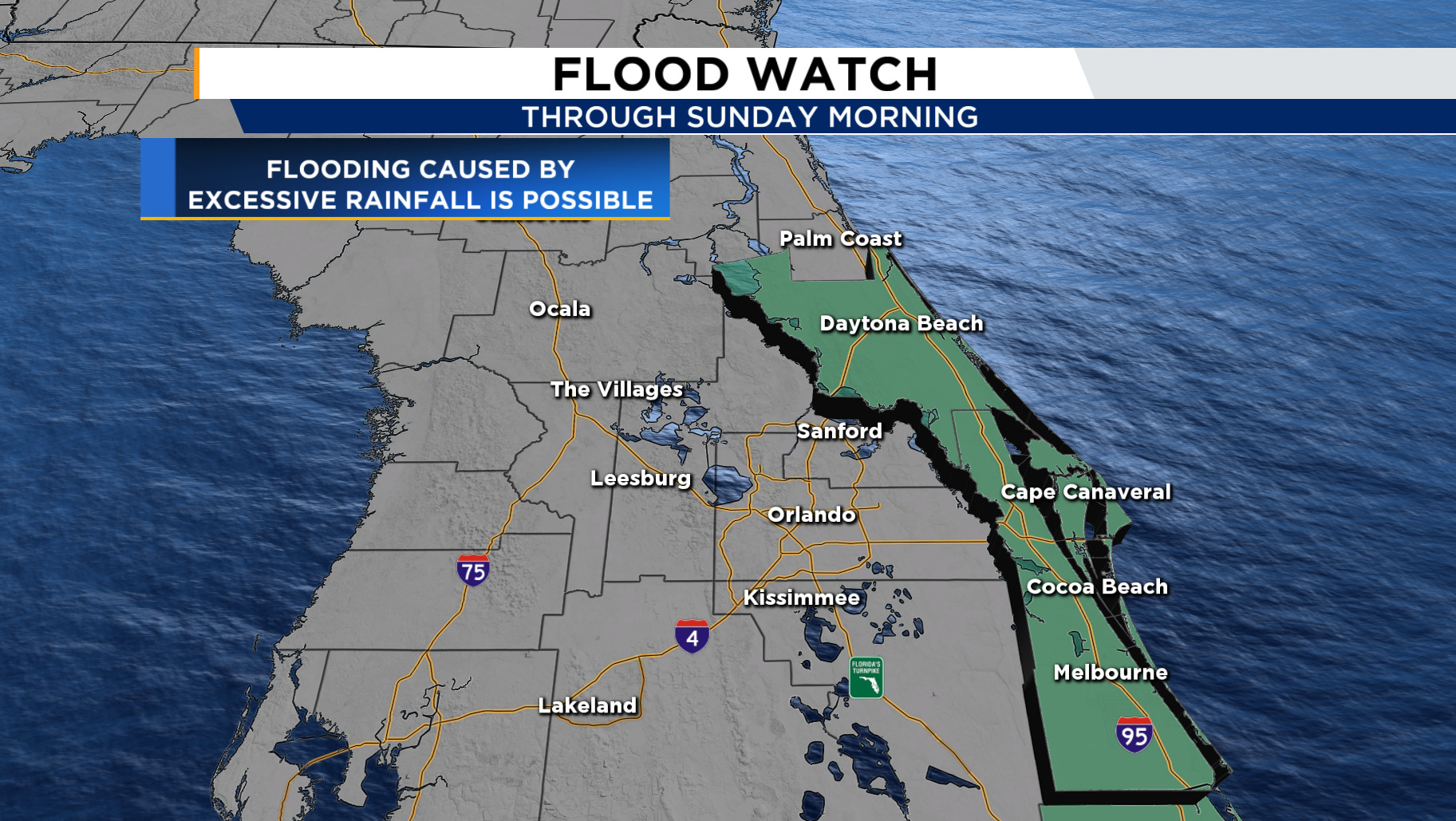
Meteorologists warn that the storm system will stay active through Monday evening and bring gusty winds between 25 and 30 miles per hour. Coastal zones face an official flood watch, and officials urge residents to stay alert since soaked ground and high tides could create flooding. The storm’s strength disrupts outdoor activities and slows traffic on major roads. Although the situation remains serious, experts say the low pressure system driving this disturbance will not develop into a tropical storm.
Deep tropical moisture streaming north from the Caribbean and the Gulf of Mexico drives the weather system affecting Central Florida. Meteorologists attribute the sustained downpours to a broad area of low pressure that has been circulating across the southeastern United States since late last week. Rain gauges from Orlando to Melbourne recorded totals exceeding several inches within just 24 hours. Neighborhoods close to waterways have seen rising levels, prompting local officials to monitor conditions closely.
Coastal regions, particularly along the Space Coast, have been warned about potential flooding during high tide cycles. Despite the discomfort, some residents have expressed relief that the rain has not developed into a more destructive tropical system. Emergency management teams remain on standby to assist communities facing drainage issues and localized flooding. The situation underscores the unpredictable nature of Florida’s weather during the transition into autumn, when tropical air masses often linger longer than expected.
A coastal flood warning now covers several counties, and officials urge residents to prepare for possible water intrusion in low lying areas. Heavy rainfall and strong onshore winds push seawater inland and strain local drainage systems. Local authorities tell people near beaches and estuaries to stay off the roads until the weather improves. Municipal agencies hand out sandbags in flood prone neighborhoods to help protect homes and businesses from rising water. The warning stays active until Monday evening and includes coastal zones that often face the heaviest flooding during long rain events. Businesses and schools near the shoreline adjust schedules and let employees work from home when possible. Central Florida knows powerful storms well, yet the length of this system makes it especially disruptive. Emergency response teams across the region focus on preparedness and urge communities to cooperate to keep everyone safe during this challenging stretch of weather.
“Read more: Why Hollywood Refused to Make Tron 3 for 15 Years, Until Now!”
Meteorologists are closely observing the low pressure system responsible for this ongoing stretch of rain, yet forecasts suggest that tropical development remains unlikely. Atmospheric conditions over Central Florida are not currently favorable for cyclone formation, as upper level winds are dispersing much of the storm’s energy. Instead, the system is behaving like a stationary front, feeding moisture into the peninsula from the south. The combination of warm sea surface temperatures and a slow moving pressure gradient has prolonged rainfall intensity across inland and coastal zones alike. While no official tropical storm warnings have been issued, the heavy rains have still led to standing water in many communities. The National Weather Service continues to emphasize caution, reminding residents that flooding can occur even without named storms. This weather pattern demonstrates how non tropical systems can still produce significant regional impacts when combined with consistent moisture flow and wind convergence.
Relief appears on the horizon as meteorologists predict a shift in weather patterns by midweek. Dry air from the north will sweep into Central Florida and push away the moisture that caused the recent soaking rains. As the atmosphere stabilizes, skies will clear, and temperatures will climb into the upper 80s by Wednesday afternoon. The return of sunshine gives residents a chance to dry out and enjoy outdoor activities again after several stormy days. Forecasters urge caution because the ground still holds plenty of moisture, and puddles may linger for several days. Farmers and gardeners appreciate the rainfall that enriched their soil, yet they hope for steadier conditions after such an extended wet stretch. This move from heavy rain to drier and warmer air reflects a common early October pattern in Florida and shows the region’s gradual shift back toward a calmer and more predictable seasonal rhythm.
This article is sourced from www.yahoo.com and for more details you can read at johnhawkinsunrated
Writer: Sarah Azhari
Editor: Anisa
John Hawk Insunrated - Viral phenomena shape lifestyle trends at an unprecedented pace, influencing how millions express themselves and adapt…
John Hawk Insunrated - Viral phenomena shape lifestyle trends at an unprecedented pace, influencing how millions express themselves and adapt…
John Hawk Insunrated - Finding yourself in FOMO presents significant challenges as the fear of missing out shapes social behaviors…
John Hawk Insunrated – this season's most anticipated releases have sparked widespread debate, with blockbuster movies season disappoint emerging as…
John Hawk Insunrated - Nostalgia culture dominates trends in 2026 as consumers increasingly seek comfort and connection through memories of…
John Hawk Insunrated - The ability to turn pop culture trends into creative hobbies can transform everyday entertainment into deeply…